woensdag 20 september 2023

Adventures and Deeds in the Yondershire

The Yondershire area is a very good alternative for hobbitplayers (lvls 20-25) who do not want to play the man quests in the North-downs. Just go to Needlehole in the Shire and pick up your first two quests for the Yondershire!


Quests in the Yondershire
The quests in the Yondershire have a very typical 'hobbit' theme. As usual, there are quests that let you run from postoffice to postoffice, avoiding nosey hobbits. And there are also 'search' quests for missing hobbits and objects. Of course there is some mushroom and strawberry hunting, you can feed all kind of animals and at some places you can help with the beer or breakfast preparation. 

You can play a hide-and-seek game with an Gildor Inglorion and the kids, 

Sometimes your quests looks like a job of social worker: you have to calm offended hobbits, must resolve a bullying incident or collect signatures for a petition. 

Some quests are typical slayer-orientated, but most are friendly hobbit quest to help hobbits in need or in distress. If you don't mind slow levelling, than the Yondershire is a great area to have fun with Lotro!


Mischief in the Yondershire with Dinodas Boffin
One of the most funniest quests  (lvl 20) are the quests which let you do some mischief with a very playful hobbit kid: the famous Dinodas Boffin. With him, you will enter a quite hilarious questchain with several quest-assignments! It actually starts with the quest 'A Visit to Yondershire', which was given to you by Bingo Boffin near Needlehole. One of the tasks that you will get, is to find Dinodas Boffin in the settlement of Gamwich

At some point, Dinodas Boffin will ask you to help you with a housewarming present, and from than on all the mischief will begin! If you follow the questchain, you will meet up with Dinodas Boffin during the following three quests: 9 Honeymead Lane, followed by Dinodas in Distress and finally with A Caper on Honeymead Lane. After resolvong these quests, you have to do some other tasks, starting with the quest 'Boffins on the Loose'. Please, do all the tasks of this quest, since it will ends with one of the most funniest instances in the Lotro game, called 'A Very Boffin Housewarming'. As you can see, I don't give clues, since it will spoil all the fun of the Dinodas Boffin quests. If you do them, you will remember him forever.

A meeting with Dinodas Boffin, somewhere in Nobottle, to do some mischief...

Sites of Yondershire (Deed)
One of the Deeds in the Yondershire is to visit the Sites of Yondershire. First, you can pay a visit to the hobbit-settlements of Nobottle, Gamwich, Long Cleeve and Tighfield. If you ride quickly along the roads to these places, there are no noteworthy enemies you will meet. If you do it early in the Yondershire area, don't forget to visit the stables, since that will open the travel routes to these settlements.

After visiting the hobbit-settlements, it is time to do some ruins exploration. Troughout the Yondershite area there are 5 named ruins, which are inhabited by quite large groups of unfriendly ruffians, goblins or half-orcs. A rough location of these ruins are given on the map below. I dont give coordinates, since it will spoil all the fun by finding them. The map is accurate enough to find the ruins, althoug sometimes you have to look carefully where the entrance is situaties. Ruins along the road are: Bâr Faroth, north of Long Cleeve, and Tham Amothir, west of Tighfield. The entrance of Bâr Faroth is on the eastside, just circle the stonewall in an eastwards direction and you will find it.The entrance to Tham Amothir is also a bit hidden. Just follow the road westwards until you pass the ruin, which is build high on a hill. After you have passed the ruin, look for a small path going uphill (left of the road, at the southside of the road).

The other three ruins are situated in the wilds, they are Lhúngobel, in the outer northwest, Ost Lagorath above Gamwich and Taerhad, east of Long Cleeve and north of Bullroar's Way. As soon as you have visited these 8 sites, you have completed the Sites of Yondershire Deed. As you can see, I don't give coordinates, just try to find these sites with help of the map below. It is way more fun!

Deeds in the Yondershire: visiting settlements and ruins

Hunting insects: the Insect Slayer Deed of the Yondershire

There are two kinds of insects that will contribute to your Insect Slayer deed in the Yondershire. These are Kneekerbreekers (kind of swamp crickets) and Harvest-flies (kind of sickle-flies). These insect species will remind you of your adventures in the Shire, in Rushock Bog east of Needlehole. Kneekers and Swampflies are also common in Bree-land, especially in the Midgewater Marshes, east of the village of Staddle (near Bree). You can find Kneekerbreekers and Harvest-flies near streams and especially in boggy areas of the Yondershire. On the map below I have added some, but not all, locations where you can find them. Just look at clusters of green squares (Neekers) and lilac diamonds (Flies) on the map. A very good place to go for kneeker-hunting is the bog in the east of the Yondershire, at 35.3S, 88.1W. Lots of Harvest-flies can be found east of Thâm Amothir, at 27.3S, 83.9W. The fly around a stone circle with five ruined pillars.

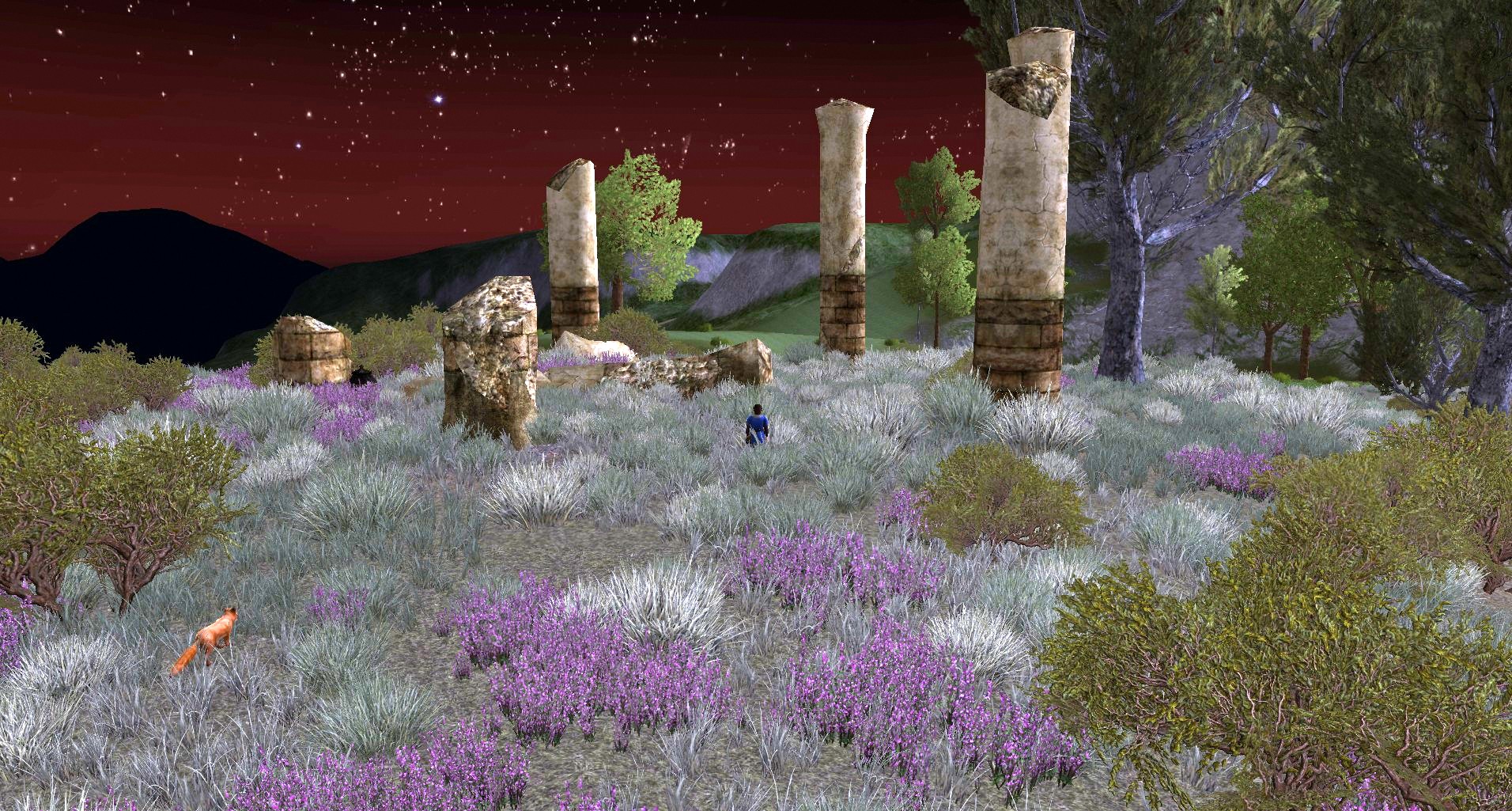
Many harvest-flies can be found around the stone circle near Tighfield (27.3S, 83.9S)

Note: harvest-flies in the Lotro game do not have a good resemblance to the harvestflies of our human world (real life), which are big cicadas. In the Lotro game they are unique fly-like insects with a sting like a wasp. In the game the harvest-flies are huge and they look a bit like a genetic cross-experiment between a cicada (body, legs and head), a wasp (sting) and a caddis fly (wings and flight behavior). 

Hunting mammals: the Beast Slayer Deed of the Yondershire
Three kinds of mammals will contribute to your Beast Slayer deed in the Yondershire. These are bears, Wolves and Shrews. Wolves and Bears dwell mainly in woods and along forest edges, while shrews can be found in the grassy open fields or along grassy roads. All these mammals can befound scattered throughout the Yondershire. There are two bear-dens and one wolf den with 15-20 animals of these species. They will contribute hugely to the Beast Slayer Deed of the Yondershire if you can locate them. The Wolf den is in the woods northeast of Gamwich, around 23.4S, 81.2W. Just look at your radar if you are level 20-25, and as soon as you see a cluster of red dots you have found the den. The bear den in the West, at 23.3S, 85.6W, can be located using the same technique. However, you have to go into the wilds and cross one of the streams to reach the den. Is is at a somewhat higher location, with trees and boulders. The other bear den is harder to find. It is located at the south side of the road from Nobottle to Bullroarer's Way. Look for a gap in the stone wall, along the road. This gap is is located at 25.5S, 76.1W. Cross the gap in the wall southwards, walk a little bit higher, to the southeast and look for a narrow valley between two rocky outcrops. Around 25.7S, 75.4W, many red dots on your radar will appear: you have found te well hidden Bear den of Bullroarer's Way!

Deeds in the Yondershire: Beast Slayer Deed

Pass the stone wall and go up between the rocks to find the Bear Den of Bullroarer's Way

The hidden Bear Den of Bullroarer's Way: look at the red dots in the radar!

Hunting for the bad guys & girls: the Enemies of Yondershire (Slayer Deed)
Enemies of the Yondershire can be easily found by using your rader (at level 20-25): if you sea many read dots around the below depicted places on the map, you have found them! The bad guys and girls of the Yondershire are thieves and ruffians, and they live in derelict places like the elven ruin of Ost Lagorath, north of Gamwich. Another concentration of thieves and ruffians lives east of Tighfield, just west of a straight and low stone wall, with some ruined pillars. This ruined place with no name, I call it 'The Straight Wall'), is around 26.6S 84.5N. It lies a bit west of the harvest-fly concentration at the pillared stone circle (see pictures below). To enter this place, you have to go uphill at the road between Tham Amochir and Tighfield. Just look for a straight stone wall with an arched stone gate. You can see the straight wall as a thin black line in your radar, with lots of red dots behind the wall (see picture below). The wall can even be seen on the map, if you look careful you see a very thin and straight line, pointing northwards. 

The other baddies are goblins and halforcs. Lots of halforcs live in the elven ruins of Tham Amothir, in the southwest, and also in the ruins of Tearhead, north of Bullroarer's Way. Goblins dwell in two other elven ruins. One is situated in the far northwest, and is called Lhûngobel. The other goblin infested ruin is Bâr Faroth and lies north of Long Cleeve. 

Deeds in the Yondershire: the Enemies of the Yondershire

Thieves and ruffians at the Straight Wall. Look at the radar and you see the wall.

Cowardly Boggarts
Throughout the Yondershire, there are also small roaming bands of Cowardly Boggarts. These small goblins comes in groups of 4-6, and they run like madman through the countryside - even along the road from Nobottle to Bullroarer's Way. I have not included all of these roaming Boggarts, the map depict just some of them I have met on my travels. You can recognise these mad goblins in your radar: look for a small moving cluster of 2 or 3 red dots. Just point your mouse above such a red dot, and you will find out if it is a group of Boggarts. They are usually level 20-21, but can be a nuisance if they popup screaming while you are fighting other creatures in the Yondershire.

Four Cowardly Boggarts attack with their pointy spears


dinsdag 19 september 2023

Travelling to the Yondershire

 The Yondershire is the new north-western hobbit-region added to The Shire in April 2022 (update 33). In fact it is the same area as The Shire, and you can see this clearly when you make use of the stables for travelling within The Shire. Access to the quests requires the Yondershire quest pack, but is free for players with a VIP account. Quests in the Yondershire are mainly intended for toons of level 20 - 24. You can also start at level 18 or 19, but at these levels most of the quests will be red. 

The Yondershire area (the red dotted line is the boundary between The Shire)

Lore of the Yondershire
The Hobbits from Bree got official permission from the high king of Fornost (Argeleb II) in T.A. 1601 to settle the land between the Brandywhine River and the Far Downs. The total area was about 21,400 square miles and was divided into four subregions of the Shire: the four farthings. There were cooler and drier fields in the Northfarthing; downlands in the Westfarthing; sheltered coplands in the Southfarthing and the mixed lands in the Eastfarthing - consisting of woods, marshes, croplands and quarries. A little east of Bywater there is an official 'three farthings point', where the three borders of the West-, East and Southfarthing come together into one single point. On this  location, the Hobbits have erected the Three Farthing Stone. This landmark can be seen at 32.2S, 69.6W near Bywater, near Tom Cotton's farm. The location and a scenic view of this landmark is presented below.  (Note: actually there is another three farthings point, just east of Overhill. At this place the borders of the West-, North- and Eastfarhing come together. However, the hobbits have not erected a special landmark on this spot).

Location of the Three Farthing Stone in The Shire

The Three Farthing Stone as seen from Tom Cotton's Farm

Enjoying a close view of the Three Farthing Stone

Later in history, the Eastmarch (Buckland) and the Westmarch were added to the Shire. The Eastmarch was occupied in T.A. 2340, almost 700 years before the War of the Rings. The Westmarch was granted by Aragorn, 32 years after the end of the War of the Rings. 

By playing Lord of the Rings Online, the Eastmarch is the area east of Combe and Staddle. The Westmarch is situated east of Gamwich and Tighfield, and only a small part is accessable in the game. South of Foxden Heath and the Shire Homesteads - near Michel Delving - lies the Southfarthing. Since the start of LOTRO in 2007, this particular area of the Shire is still inaccessible. In the map below you see the boundaries of the Northfarthing and the Westfarthing.

In the Tolkien's books, and especially in 'The History of Middle Earth' by Christopher Tolkien, there is no mention of the Yondershire. So, this area should be interpreted as the lands, ruins and settlements 'beyond' the Hill, west of Bilbo Balings home. If you look at J.R.R. Tolkien's maps, and especially at the maps in the Atlas of Middle Earth by Karen Wynn Fonsted & Christophor Tolkien, you will see that the Yondershire contains both the Northfarthing and the Westfarthing. A correct picture of the boundaries of these farthings in the LOTRO game can be seen below:

Farthing boundaries within the Yondershire (S = Southfarthing)


As you can seen on the map above, the Westfarthing contains not only the Yondershire area, but also a small partion of LOTRO's 'The Shire' area, with Needlehole, Little Delving and Michel Delving.


Traveling to the Yondershire
If you are in the Shire, and you have never visited the Yondershire, you can enter this area by following the road westwards from Needlehole. Just pass through the Rushock Gate and you will enter the Yondershire.
If you are in the tiny settlement of Little Delving, you can enter the Yondershire by following the road in north-western direction. You will soon enter the Yondershire and arrive at the settlement of Foxden Road. If you want to travel through the wilds, you have to go to Rushock Bog. Go to the centre of this boggy place ant travel in a western direction: you will soon enter the wilds of Yondershire, east of the Foxden Road settlement. Another option, is travelling from Ered Luin. Go to Duillond, cross the high bridge across the river and go in eastern direction. After a while you will enter the Yondershire, but it will take a while before you will reach the first settlement: Tighfield.

If you have already visited one of the stables of the Yondershire, the most convenient way to travel to this region, is by hiring a horse at a stable from Michel Delving in the Shire. Just choose one of the stable destinations in the Yondershire, like Nobottle, Tighfield, Foxden Road or Gamwich.


Starting the questline for the Yondershire
As soon as your adventurer reaches level 19 or 20, you can start with the first quest 'To Yondershire' in Needlehole, in the northwestern part of The Shire. Travel to Needlehole, pass the hedge gate and find Bounder Chubb next to the corner of the gate. Pick up your first Yondershire-quest: Bounder Chubb will ask you to pay a visit to the dwellings of Nobottle and Tighfield in the Yondershire. 

Bounder Chubb in Needlehole

After you got the quest from Bounder Chubb, follow the road westwards, cross the two stone bridges, and go through the Rushock Gate. After passing this gate, you will find Bingo Boffin along the road. Bingo will give you the second Yondershire quest,  'A visit to Yondershire', which directs you to Tighfield. Go through the stone gate which can be seen behind Bingo and turn left, e.g. westwards: your adventures in the Yondershire (aka the North- and Westfarthing) will begin!

Below is a graphic report of my travel to the Yondershire, picking up quests from Bounder Chubb and Bingo Boffin. I came from the road northy of Rushock Bog and arrived at the little settlement of Needlehole. Directly after passing the Hedge Gate, I found Bounder Chubb.

Location of Bounder Chubb in Needlehole

After I got the quest, I travelled westward, following road which is directly adjacent to the river, which is simply called The Water. The Water is actually a short name for Shire-water, a river which runs through both the Shire and Yondershire areas. It is feeded by two streams at Tighfield and Long Cleeve, their waters joins at Nobottle with 'The Water'. From Needlehole, 'The Water' runs eastwards into Rushock Bog, then it flows to Hobbiton, Bywater abd the marshes of Frogmorton. Finally it joins the Brandywine river near Stock, north of the Brandywine Bridge.

To enter the Yondershire, I followed the path westwards along The Water, first crossing a high stone bridge. After a while I crossed The Water again, now travelling over a low stone bridge. Shortly after, I arrived at Rushock Gate, which is also a Hedge gate - like the one in Needlehole.

From Needlehole to Rushock Gate

The high stone bridge across The Water, near Needlehole

The low stonebridge across The Water, near Rushock Gate 

At Rushock Gate, I saw Bounder Dogberry, who waved me goodbye when I travelled through the beautiful ivy hedgegate.

Bounder Dogberry at Rushock Gate

After passing the hedgegate, I entered the Yondershire. Soon I saw a low stone fence, with an arched stone gate. A friendly hobbit in a green jacket was standing near the road. It was Bingo Boffin, who gave me a quest to visit hobbits in the settlement of Tighfield.

Bingo Boffin and the stone gate to the Yondershire


maandag 4 september 2023

The Dutch Maps of Middle Earth, made by Cees Kelfkens

For all players who love the maps in the game, this blog is dedicated to three Dutch maps, drawn by the Dutch artist Cees Kelfkens (1919-1986). 

The story goes as follows....


I have three old dutch Lord of the Rings Prisma pockets from 1976. From the moment I got these books, I loved the map art of three maps, which were enclosed in these pockets. In part I (The Fellowship) there is a beatiful map of the Shire by Cees Kelfkens, based on Tolkiens own map. You can see the name of the artist in the left bottom corner of the map, just by a capital 'K' or - on the Rohan map - by his family name, Kelfkens.

Map of the Shire

Dutch map of the Shire ('De Gouw'), drawn by Cees Kelfkens

As you can see, all the topographic names were translated in Dutch. For a young Dutch reader this was great, but years later - when the movies and LOTRO were released, it was a bit difficult to translate them directly into the original English name, devised by Tolkien. You need the original Tolkien Map to know which Dutch name refers to which English name.

For comparison: here is the original map made by Tolkien of the Shire:

Original map of the Shire, as drawn by J.R.R. Tolkien

Map of Rohan

In part 3 of the Lord of the Rings trilogy (Dutch version), there was an intricate map of Rohan. It was republished in the one volume collectors edition in 2003. Unfortunately, the reproduction of the map had a fold in the middle, which makes the map not very easely readable in the centre parts. I made a scan of my 1976 pocket book and reworked it in Photoshop. Here is the final result:


The Lord of the Rings: Rohan map by Cees Kelfkens

As you can see this is a great map, drawn in the cartographic tradition of the old Dutch map makers, like Joan Blaeu in his Atlas Maior. This map was already enclosed as a folded map in the first Dutch edition, which was released in 1956-1957. Below is an impression of the first printed Dutch Rohan map, as photographed by the Tolkien shop, Leiden, The Netherlands.

Gondor map in the first Dutch edition of Lord of the Rings (1956-1957)

Most of the names on the Dutch map are recognisable, but some are lost in translation. For easy comparision of the English names, you can look them up on the original map, drawn by J.R.R. Tolkien, see the map below.

Original map of Gondor, as drawn by J.R.R. Tolkien


Map of Middle Earth

I do not remember in which volume the big folded map was enclosed, since I have used it over and over to look at all the details. It was first published in 1956-1957 as a big, folded map in the first Dutch edition of the Lord of the Rings. In the pocket series it was enclosed as a white, folded map, sized between A4 and A3. As you can see clearly by the 'K', this map was also drawn by Cees Kelfkens. I have scanned the map and reworked it, to remove the folds (and their shadows). The result of the scanned and enhanced Kelfkens map is presented below:

The Lord of the Rings: Middle Earth map by Cees Kelfkens (1976 printing)

Below a picture of the original 1956-1957 map, as can be seen at the Tolkien Shop, Leiden, The Netherlands:

The Kelfkens Middle Earth map of 1956-1957 (Tolkien shop, Leiden, Netherlands)

As you can see on the scanned map above, the map is a real beauty of art. I love the Dutch map, even if the names where translated in Dutch (and sometimes got lost in translation...).

Below you see the original map of J.R.R Tolkien, which is preserved in the British Library:


Original map of Middle Earth, drawn by J.R.R. Tolkien


vrijdag 28 juli 2017

Deeds in Forochel


Forochel is a beautiful place, with some interesting deeds. There are four groups of deeds:
1. Explorer of Forochel
2. Forochel Pioneer
3. Slayer of Forochel
4. The Lost Fellowship


1. Explorer of Forochel
To complete this group of deeds, you have to explore the harsh but beautiful and icecold wilderness of Forochel. For this, you have to explore the key battlegrounds of Forochel (Battle of Forochel deed) and to visit the old dwarven ruins. So, you need to complete the following:

The Battle for Forochel
Discover and visit four key battlegrounds of the Ice Bay of Forochel. Key battlegrounds could be blue or red, depending wich force controls them (red = evil force of Angmar, blue = free people of  Middle Earth). 

Hylje-leiri is the Camp of the Seal. It is a small hunting-camp which can be found at 18.8N, 81.3W.

Karhu-leir is the Camp of the Bear, ant this hunting-camp can be found at 12.9N, 66.3W.

Pynti-leiri is the Camp of the Hunt, and is one of the more popular hunting-camps of the Lossoth. The camp can be found at 8.8N, 70.5W.

Norsu-leiri is the Camp of the Mammoth. This hunting camp was established by the Lossoth to hunt mammoths and can be found at 8.0N, 78.9W.


Ancient Stones of Forochel
Although the Lossoth of Forochel are not great builders - they build small temporary settlements with iglo's or tents - there can be found some interesting old buildings scattered over this region. All these buildings where build by dwarves a long time ago, and one has even an underground mine. To complete this deed, find all the old dwarven ruins.

Kibilzahar: in an age when Dwarves mined the crags and bluffs of Forochel, they built many fortresses. Kibilhazar is one such place, though it has been long abandoned. Rumour has it that the place is infested with undead creatures. But as you know, rumours run wild among old ruins...  The rold fortress of Kibilhazar can be found at 20.0N, 85.0W.

The Ironspan: The Ironspan was built by the dwarves long ago, as they sought precious metals and gems in the mountains of Forochel and Angmar. When the dwarves abandoned their endeavours, the Witch-realm of Angmar wrested control of the great gates. The place is full of Angmarin and can be found at 17.0N, 59.3W

Zigilgund: Zigilgund is an ancient dwarf-site, build at southern shore of the to Ice Bay of Forochel. Recently the dwarves have returned to this remote place; it can be found at 9.5N, 81.1W

The Lonesome Stones: the Lonesome Stones is an a weary and old ruin and a reminder of ancient days when dwarves mined the crags of Forochel. It is situated at 13.6N, 74.4W.

Find Icereave Mines: the Icereave Mines long stood unused, but now the Dourhands seek to use them for their own benefit. It can be found a short distance southeast of Zigilzund, at 8.9N, 81.9W

Forochel Pioneer
The brutal wilderness of Forochel would keep all but the hardiest at bay, but for those with the spirit to endure and thrive in its environment, its call may prove irresistable at the last. To complete this deed perform the following objective(s):
Complete quests in Forochel (30)
Your efforts here in a land of endless winter have endeared you to many of the Lossoth who live in the region. Between your efforts and those of the others who have fought on behalf of these folk, perhaps the Angmarim and their allies can be hindered in their evil designs.


Slayer of Forochel
There are many villainous monsters roaming Forochel, and the Free Peoples must do their part to slay them.
To complete this deed perform the following objective(s)
Complete Slayer deeds:Angmarim-slayer (Advanced)Dourhand-slayer (Advanced)
Gauradan-slayer (Advanced)
Grim-slayer (Advanced)
Sabre-tooth Slayer (Advanced)
Worm-slayer (Advanced)


The Lost Fellowship was a brave party that set off from Angmar to find a great treasure in Forochel. Unfortunately, they encountered some trouble along the way. To complete this deed perform the following objective(s):
Aid the Champion, Déornyd [11.4N, 69.8W]
Aid the Guardian, Nef [19.4N, 71.3W]
Aid the Burglar, Warstang [9.5N, 81.1W]
Aid the Captain, Reginald Ward [19.1N, 70.8W]
Aid the Hunter, Thurmaer [19.4N, 83.8W]
Aid the Lore-master, Cenlieg [3.0N, 58.1W]
Aid the Minstrel, Burgthryth [7.5N, 75.5W]

This deed is a prerequisite for the quest [50] Hero of the Lost. For female characters, the reward title is Heroine of the Lost.

vrijdag 21 oktober 2016

Atlas of Evendim

Have you ever been in Evendim? No? Oh, you surely should go there! 
It is a beautiful region with wonderful landscapes, good weather, relaxing music, great monuments & ruins and a bunch of interesting quests. 
So, if you are level 25 to 30, just go to Evendim and level up to 38 or even 40! 

Evendim map
Traveling to Evendim
The easiest way to travel to Evendim, is by hiring a horse at a stable from Michel Delving in the Shire. Just choose destination Hobbiton. After arriving in Hobbiton, change horses at the stable and go to Brockenborings. The stable of Brockenborings is the last stop in The Shire; here you rent again a horse with destination Oatbarton, in Evendim.
If you arrive in Oatbarton at level 25, you can begin questing in the Northcotton Farm. This area is a maze like area of farms, hedges and fields, where you have to do many small farm chores. Yo will gain at least 3 levels, by looking for eggs, chickens, milking the cows, washing pigs, smoking tobacco, etc. etc.

It is also possible to reach Evendim from the North Downs, but at level 25-30 this is a dangerous route to explore. There is a stable route from Trestlebridge in the North Downs to Tinnundir in Evendim. Trestlebridge lies in the southeast of the North Downs, and you can reach it by traveling northwards from West-Breetown. Tinnundir is the ranger island in the center of Evendim. To open the route from the North Downs to Tinnundir, you have to travel westwards through the Fields of Fornost. This is a dangerous area with many undeads and fierce bargests dogs.
If you have opened the route to Tinnundir and Oatbarton, there are swift travels from Michel Delving to Tinnundir. There are also swift travels from West Breetown and Esteldin to Tinnundir, so there are many ways to ride to the center of Evendim.

Travelroute to Evendim: rent a horse in Michel Delving, and ride subsequently to the stables of Hobbiton, Brockenborings and Oatbarton
Starting Quests in Evendim (from level 25 onwards!)
Evendim is essential a level 30-40 area, but you can already start you quests at level 25! To do that, go to Ost Guruth in the Lone lands. Find a woman called Hana the Young, she resides near the tower in the central part of Ost Guruth. If you are the right level, and you have done some quests in the Lone Lands from level 18-20 onwards, you will get the quest "Oatmeal Problems" from Hana. At level 25, this quest is red (its a level 30 quest); don't be afraid of the high level quest because it is a very easy one. First you have to go to the Forsaken Inn, to speak with Anlaf. He is the bartender and will send you to Nod Gardener, who lives in Oatbarton. Just travel to Michel Delving and pick up the stable route to Oatbarton, as described above.

As soon as you arrive in Oatbarton, go to Nod Gardener, who is in the center of the small settlement. He will send you to Northcotton Farm, which is a big and maze-like farm complex uphill, just behind Oatbaron. You have to travel a road uphill, west of Oatbaron, and have to speak with the farmer Albin Northcotton. The Northcotton farm complex is described below.


The Northcotton Farm
The Northcotton Farm is a big farming complex within a maze of hedges. It is locates in de area of Bullroarer's Sward. Below you see a picture of the layout of the farm complex, with the main farmers and areas of the farm complex.


Layout of the Northcotton Farm complex, west of Oatbarton (Bullroarer's Sward)


As you can see, there are 7 farmers in the Complex (yellow dots), which will give you lots of chores to do. The first thing to do, is to visit Albin Northcotton at the Market Grounds. He will give you various quests, which you can pick up from farmers like Blossom Gamgee, Edulf Tunnely, Rosa Brockhouse and Gerard Deephole.

Immidately when you enter the farm complex of Northcotton, you will have the feeling that you have entered a maze of farms, fields and hedges. And yes, this farm complex is more or less a maze, but you will learn your way soon enough by visiting to the various farmers. Below you see a map of the available roads (orange-brown) and impassible hedges (green). Impassible rock outcroppings are light grey. Through the hedges there are gates, and try to memorize the locations of these passages. If you look at the map you see the hedgegates depicted with two small green bars in the openings of the hedges.
Outside the hedges there are also some farms and fields, but these are only accessible through an instance quest. This area will be discussed later.


The Northcotton Farm complex: persons, places, roads en hedges


Each farmer will give you various quests, which are actually farmer chores. They are easy to do, but sometimes the locations of the chores are hard to find in the maze-like complex of Northcotton. I have made a map for you where you can find all the quests objects of the farm chores. I will not describe the quests, since it will spoil all the fun at Northcotton! Feel free to use the map, but remember it is a spoiler!


Northcotton Farm, location of all the quest objects


After you have done al the Northcotton Farm chores, you have to help Nibs Chubb & Hal Gamgee with their troubles. Don't look for them in the Northcotton Farm complex, since they aren't there. You have to go back to Oatbarton and have to find Nibs at his farm, which is a little east of the village center. If you go a little southeast of the farm, you will see 4 hobbits staring at a Mysterious Relic. You can examine this relic which starts an interesting deed. Just see it for yourself.

The farm brothers have some quests for you concerning a mysterious curse in the meadow and disperse some nasty insects in the cornfields. Look out for a dead animal corpse in the meadow, which is the solution of one of the quests. If you have done all the quests you are directed to the peculiar cam of Dwaling, where most of the hobbit houses are conquered by thieves and outlaws. The hobbits at Dwaling give you a lot of interesting quests. Not only to disperse the thieves and outlaws, but also to investigate a dangerous goblin camp.
If you completed all the quests at Dwaling, you will be level 29 or 30.

Some quests will send you to the sands of Barandalf. Try to check your bag regularly, because some foes will drop a green weed (algae). That green weed will start a quest which direct you to a ranger camp underneath a gigantic statue, at the crossing of Lake Evendim and the Brandywine River. These series of Evendim quests can be obtained already at level 28 or 29. Just visit High Kings Crossing. You can find the statue on the map also, so it must be no problem to find the ranger camp.


zondag 11 september 2016

Index Elannah's Wonderful Lotro World

After a break of one year, I am playing Lotro again. So, good news for the scholars: I have recently updated my blog for tier 9 and 10 scholar artifacts in Gondor. The new pages can be found in the index below.

Tips

Remmirath, the Netted Stars, right above my head.

Index

1. Lotro Crafting Guide                                                     
Scholar and scholar Artifacts
Where to find Scholar Stuff in Lotro 
Where to find Scholar Stuff in Rohan and Wildermore
Where to find Scholar Stuff in Gondor and Anórien
Scholar in Lotro: making dye

Woodworker and Wood locations
How to become a woodworker
The Woodworkers Guild
Wood in Lotro - and where to farm it

Tailor and Hide farming locations
Hides - and where to farm them

Prospector and Ore locations
Ore in Lotro, and where to find it

Jeweller
How to become a member of the Jeweller's Guild

2. Lotro Deeds, Traits & Virtues  guide                             
Virtues
Valour
Zeal

Elven Race traits
Hobbit Race traits
Dwarven Race traits
Man Race traits 
 
3. Lotro Class guide                                                           
Loremaster skills: Flanking
Loremaster: using your combat pets
Loremaster: non-combat pets
Loremaster: gear and jewelry


4. Lotro Leveling guide                                                      
Levelling from 1 to 60

5. Lotro Plugins                                                                  
Huge Bag Plugin

6. Doing damage                                                                
Damage with an edge - Damage types
How to get your first legendary weapon

7. Finding fellowships                                                       
Joining a high level Instance

8. The stars and the moon in Lotro                                   
Constellations in Lotro

9. Off map adventuring in Lotro                                        
Introduction
Off Map Places in Lotro
Flying
How I learned to fly in LOTRO's Middle Earth  
The Shire
Climbing the Waterfall of Bindbole 
The Borg Cube in The Shire
Peeking behind the gate of Michel Delving 
Climbing the waterfall of Woodhall
Bree-land
The forlorn Hobbitvillage in Breetown
Lone-lands
The Hidden World behind Ost Guruth
North Downs
Exploring the secret places of Esteldin
Forochel 
Iceberg hopping in Forochel


10. Lotro Free to Play Guide                                               
Free to play guide